EADP19-001 Exam Questions & Answers
Exam Code: EADP19-001
Exam Name: ArcGIS Desktop Professional 19-001
Updated: Nov 12, 2024
Q&As: 93
At Passcerty.com, we pride ourselves on the comprehensive nature of our EADP19-001 exam dumps, designed meticulously to encompass all key topics and nuances you might encounter during the real examination. Regular updates are a cornerstone of our service, ensuring that our dedicated users always have their hands on the most recent and relevant Q&A dumps. Behind every meticulously curated question and answer lies the hard work of our seasoned team of experts, who bring years of experience and knowledge into crafting these premium materials. And while we are invested in offering top-notch content, we also believe in empowering our community. As a token of our commitment to your success, we're delighted to offer a substantial portion of our resources for free practice. We invite you to make the most of the following content, and wish you every success in your endeavors.

Download Free Esri EADP19-001 Demo
Experience Passcerty.com exam material in PDF version.
Simply submit your e-mail address below to get started with our PDF real exam demo of your Esri EADP19-001 exam.
![]() Instant download
Instant download
![]() Latest update demo according to real exam
Latest update demo according to real exam
* Our demo shows only a few questions from your selected exam for evaluating purposes
Free Esri EADP19-001 Dumps
Practice These Free Questions and Answers to Pass the Technical Certification Exam
An ArcGIS user is making a map and needs to symbolize cliff and escarpment features above contour features. How can the features be ordered correctly if they are all in the same layer?
A. set a definition query
B. use symbol level drawing
C. use scale-dependent drawing
D. reorder the symbols in the symbology properties
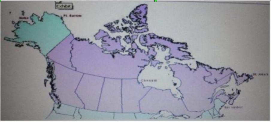
Refer to the exhibit.

The ArcGIS user is given data for the Arctic, and is asked to perform various types of analysis using the data. The data extends from the North Pole south to 55 degrees North Latitude Data layers may contain points lines, or polygons and include ice surveys from NOAA depth contours; continental margins, locations of known and suspected oil reserves, endangered species habitat and territorial boundaries for nations having Arctic coastline.
An ArcGIS user is asked to calculate the distance a cruise ship will travel through open water, departing from Nome, Alaska, with stops at Point Barrow Alaska Churchill Manitoba St John's Newfoundland and ending in Bar Harbor Maine. On
the basis of these calculations the cruise ship line will determine fuel requirements and travel time.
Which map projection yields the most accurate results for this distance calculation?
A. Albers equal area conic
B. Lambert azimuthal
C. Mercator
D. azimuthal equidistant
A water utility company had received calls fromseveral customers complaining oflow water pressure.
Using a geometric network representing the water network, how can an ArcGIS user determine the most likely location of the problem?
A. place junction flags on each customer water meter and use the Find Common Ancestors trace task
B. place junction flags on each customer water meter and use the Find Disconnected trace task
C. place a junction barrier on each customer water meter and use the Trace Upstream trace task
D. place a junction barrier on each customer water meter and use the Find Path upstream trace task
An ArcGlS user created a geoprocessing script in which the output layer's symbology property is set to an existing layer file. The user intends to share the tool with another ArcGlS user. How can the user share the script tool while maintaining the symbology in the output layer?
A. Share the script tool while the sumbology layer file embedded in it
B. Publish the script tool as a geoprocessing service to ArcGlS Server
C. Distribute the Toolshare folder containing the script tool and related data
D. Upload the script tool as a model to an FTP site
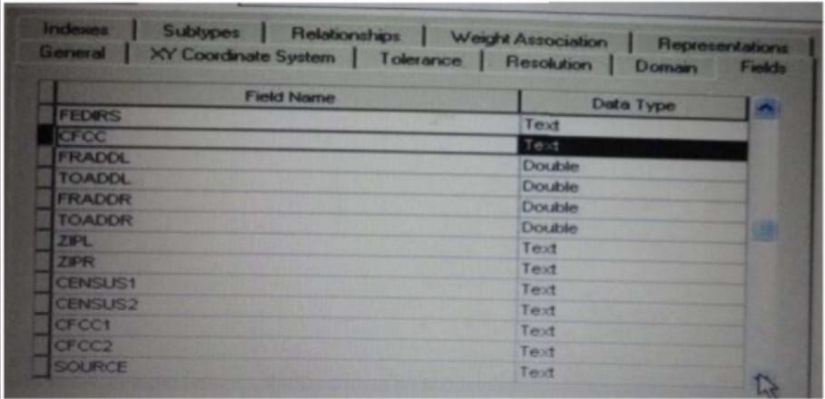
Refer to the exhibit.

Which change needs to be made to the table in the exhibit in order to create subtypes based on the CFCC field?
A. A new field should be created to migrate the text values of CFCC to integers
B. A default CFCC value should be assigned
C. The data type of the CFCC field should be changed to Long integer
D. The allow subtypes property should be set to True
Viewing Page 1 of 3 pages. Download PDF or Software version with 93 questions

